 Day One: Saturday’s route was mostly similar to last year’s, taking us from the took us from the Tamástslikt Cultural Institute to Pendleton, west to Echo, north to Hat Rock state park and back southeast to Pendleton. Because it was a little rainy when we started, I wasn’t paying much attention to the lack of Dan Henry markers and started replaying the initial part of last year’s ride among the rolling roads south of I-84. Hence, I had some bonus mileage.
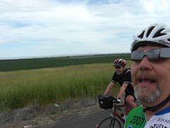
We followed Old Pendleton River Road (aka “County Road 1300”) westbound to the town of Echo. Except for the occasional chunks of rocks crumbling down from the ridge to the north, this is a lovely road, snaking along the Umatilla river. I stopped frequently to take photos.

The first official rest stop for the day, Kamaniwanaleiu, was in the town of Echo. Here, I ran into the Green River Riders — John, Kevin, Rod and Lee. I had an embarrassing moment when I had a mouthful of food and John made a comment to Rod about a bicycling doodad. It was fitting that I stayed at the back of the pack until I could, um, clean up the mess.
Eventually, John, Kevin, Rod and Lee had gone on ahead. I caught up with them in Hermiston when they were coming the other way to tell me “turn around.” One of the many trains plying Pendleton was Not Going Anywhere For A While. Apparently there were people who were carrying their bikes over. I kept thinking of Scout’s blog on this. (The danger: if the train starts to move, it lurches. Riders on fancy schmancy bike shoes are likely to slip. The train, being heavier, will always win.)
When they went over the route highlights Friday, they cautioned us about the two mile stretch leading up to Hat Rock State Park. State Road 730 actually was fine for me, though it was another example of what I’ve gotten used to (with a tablespoon of cognitive dissonance). For example, last month I recommended “ride uphill on the sidewalk, against traffic, because you’ll never be able to make the left turn” and realized how insane these instructions sound to someone else. The roads in my nook of unincorporated King County suck, and it’s what I have to work with if I want to ride.
 After Hat Rock State Park, there’s a gradual climb back up to Pendleton on nearly-deserted roads and past dead, stinky coyotes. Though they warn riders to practice save hydration, this stretch always seems hotter than it really is. As we got closer to the final official stop, we saw Burma Shave-like signs teasing us about the upcoming Susie’s Diner. These were surprisingly motivational. The fountain drinks and hamburgers did not disappoint! (Thanks, Sue)
Once in Pendleton, I dropped off a bunch of items (camera, water bladder) at my motel room and continued to the Tamastslikt Cultural Institute, where my car was. (Next time, I’ll just start and stop from the motel like John and the others did.) Back at the motel, again, I washed up and, still full from Susie’s burger, skipped out on the dinner at the casino. I drove up for the slide show and a great post-ride massage from Mars, who remembered me from last year.
106.6 miles (including side tracks), 2,700′ elevation gain, 7:28 on the bike. Moving average: 14.2.

Day Two: If the weather had been as good as Saturday, this would have been an awesome route. Fog limited the visibility to a few hundred feet. Cabbage Patch Hill was one of those “as long as I keep pedaling, I’ll stay warm” climbs. I dawdled at Deadman’s Pass rest stop on I-84 and got the shakes. Instead of continuing to Meacham and, later, the Oregon Trail Interpretive site, I opted to head back. Before I left, the volunteers gave me a much appreciated pair of the disposable rubbery gloves to don underneath my thoroughly wet ones. It took about 45 minutes go downhill and back to the TCI – just over a third of the time it took to go up.

I cashed in my “CROC bucks” for a ginormous mocha, then drove back to the motel to shower. Room service hadn’t come yet, so I had to reuse a towel from the night before. Since my shoes and Camelbak were soaked, I stacked them on top of the motel air conditioner and went to tour the TCI. The museum was worth visiting.
32.6 miles, 3,000′ ascent, 2:45 on the bike. Moving average: 11.9.
Day Three: It’s too bad the Bar M ranch is being sold because the overnight stay there was very charming. There was an out-and-back route (50 miles) that was typical Pendleton: no traffic, good pavement, beautiful scenery (the Umatilla river). It made me forget yesterday’s weather 😉
For the overachievers, there was an opportunity for bonus mileage that also included a nice climb up Thorn Hollow. We had been on this road last year, but going down. Let me tell ya, that’s faaaaaaar better going up because there’s more time to enjoy the awesome beauty. The grade wasn’t particularly hard, but I stopped a lot to take photos 🙂

They routed us on a counter-clockwise sweep to avoid the small stretch of Highway 11. I was tempted to bypass this section when I realized how out-of-the-way this was going to be, especially since the sun was beating down on me. However, I was feeling a little guilty for bagging yesterday. For me, this was the hardest part of the ride. Once I was pointed back towards the TCI, I had a set of rollers that livened it up. (With rollers, I think you want to power down the hill so momentum takes you up the next. I have a lot of momentum to work with. I reached the TCI around 12:30.
I used several baby wipes to clean up some before putting my civilian clothes back on. On the way out, I picked up few post cards to send. I was writing those in the parking lot when three buses pulled up to deposit Old People at the TCI. It was time to head out.
70.1 miles, 2,900′ ascent, 5:24 on the bike. Moving average: 13.0.
