 Booyah!
To add variety to geocaching, “blackouts” challenges are posted whereby one has to find a slice of geocaches in an area. The last one I did was the Bellevue Blackout, which was nicely constrained within the city limits of the town I work. It took me about two years to finish.
Other blackouts have included much wider geographical areas like the Delorme challenge, where you find a cache in every page of the Washington Delorme map book. Since they’re so far away from being attained, I’ve been content to ignore them.
 The trail had completely washed out. Only way through was to cross over this, climb on the non-trail, and cross again. This was our favorite of the day. That black rock Kurt’s standing on is coal.
Recently a Tiger Mountain blackout was posted. Cache owners are given some latitude (pun intended) in qualification requirements. Kurt, who owns this one, offered two ways to complete it: 1) a Hiker version, which include all non-puzzles and was limited to the park boundaries; 2) a geopolitical version, which is the triangle bordered by the three major highways and included everything except another challenge that no one’s completed yet. With a lot of potential hikers finishing the first, but not wanting to do the puzzles, Phil, Bob and I opted for the second one.
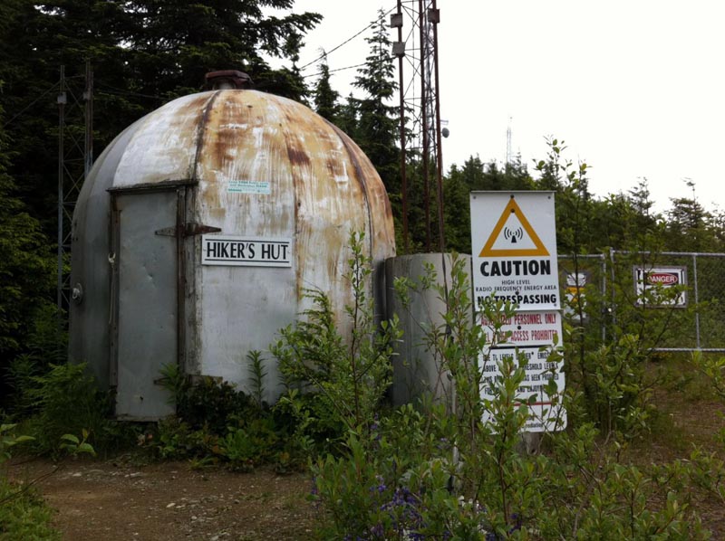
 Hiker Hut for inclement weather … or recharging your iPhone
The state forest is very close to home, has a lot of caches, and best of all, I’d done all of the insanely difficult puzzles and multis last summer with my friends Bob and Phil. Unfortunately, since starting my new job, my caching’s dropped off a little bit. This was an opportunity to focus on a specific goal.
 Maybe more than a little bit.
When we started in June, I had found 103 caches, about ten fewer than Phil and Bob. Phil did a lot of work plotting optimal routes to pick up the ones we had in common. Since these were all over the mountain(s), this usually resulted in through-routes, where we’d park a car at both sides and hike the ~8+ miles in the middle.
 1925 Train Wreck, Tiger Mountain State Forest
Since this was still June, we sometimes got rained on. A lot. The worst was after visiting the highest point on the mountain. Within a few minutes of our lunch break, the rain started. We were thoroughly drenched when we reached the car.
 Lunch break near 1575.45MHz – about five minutes before the deluge.
I think rain is worse than snow sometimes.
 Snow-covered, blown down trees. But at least I was dressed for it.
Of the 135 caches found, there were 98 traditionals, 26 puzzles and 11 multi caches. Six of them were perviously DNFS — some multiply so. My percentage here is lower than normal because Phil and Bob are better at finding things.
 Another oddity found while visiting Tiger Mountain – Alternative entry to The Swan?
There were 65 cache owners with placements, but two accounted for over 25% of the ones found. Both liked long hikes on uncrowded trails.
 Oh, man, can I hear you now!
The highest cache was one called 1575.42MHz at 3000′ elevation. The lowest was the Issaquah Photo Mystery Tour. Average elevation: 1184′ According to the stats program I used, I’ve covered 204 miles of hiking during the last four years. That qualified me for a “hike 100 miles” challenge, which I still need to go out and find.
 MTM – four waypoints, one near each mountain peak. *Not* a single trip.
The hiking on the mountain was always challenging. Twice, we encountered trail washouts. Or blowdowns. I needed to find one of the caches that Phil and Bob found in 2010. In the ensuing two years hence, a wind storm had blotted out the trail. Climbing over, under and through a half mile of fallen trees (0.3 in, 0.25 out) in shorts is about as fun as it sounds, but I was not going to let this deter me. My legs got soooo scratched up.
 Trail? What Trail? Two star terrain? Coming out was slightly less bad.
On our penultimate trip out, a new cache was published in the boundary. After the sinking feeling lapsed, we saw it was located where we were going to visit next trip. With bonus incentive to get this done, I took off from work Tuesday and enjoyed a nice cool walk up to the final. High fives were exchanged and we agreed, it would be okay to take a break from this forest for a while.
 Mossy arch