I had a lot of fun researching the road signs and thought I’d delve into another area of mystery: roads themselves. So today, I’ll look at weird things like road striping, road dots, and the interstate system in general.
The lines on highways are 6″ wide. Dashes are 30 feet apart and 10 feet long. They’re made with either paint or tape.
Road paint is one of three types: water base, polyester or epoxy. Under ideal conditions (temperature/moisture), it takes 3 minutes to dry. 16 gallons of paint are used per mile of line. Glass beads (96 pounds per mile) are mixed into the paint to make it reflective at night. Paint costs $5.00 per gallon (yellow or white), and glass beads are $0.14 per pound, probably cheaper in bulk. (I’ve seen numerous spams from China buying these in 10 metric ton lots. Don’t know where I’d put them…)
Reflective tape is sometimes used as an alternative to paint in areas requiring multiple repaintings a year. Think urban. You can buy a 90′ spool of 6″ tape, in either yellow or white, for $341.50.
But what about the lane dots? Glad you asked.
Reflective pavement markers were adopted for use in California in the 1950s (from British invention during WWII). The intial model, known as “Bott’s Dots,” after Dr. Elbert D. Botts, were raised and had the added benefit of providing vibrational feedback to drivers straying from their lanes. Unfortunately, they weren’t very visible at night, and the Stimsonite company (now a subsidiary of Avery Dennison) was asked to to redesign them. The initial designs were very successful, but areas using snowplows necessitated further design refinements in the 1970s.
Reflectors are made of acrylic plastic covered with a thin glass layer. For most roads, they’re 4″ long, 4″ wide, and 0.7″ high, and weigh about 7 1/2 ounces each. Cost varies on volume, but they appear to be about $0.89 each in boxes of 100.
Installation of these is pretty straightforward: clean and dry the surface (usually with a sandblasting apparatus), apply adhesive, and press into place. Also interesting: reflectors are “self-cleaning.” They assume that people are going to hit them and the tires wiping over them removes road grime.
In areas where snowplows are used, reflectors embedded within a cast iron housing are used. These are 10″ long, 5 1/2” wide and almost 2″ high, though all but 1/2” of that is stuck into the road. The iron housing adds a lot of weight, making these babies top out at 5 1/2 pounds each. I wasn’t able to find any pricing on these, but they’re likely to be substantially higher because of the iron casing and you won’t get super saver shipping!
Reflective pavement markers have a useful life of 4-10 years, and the iron casings of the snowplow versions can be reconditioned.
Highways
Contrary to the urban legend, the interstate highway system was never designed to be used for emergency airstrips in case of war. (Source: Richard Weingroff, Federal Highway Administration) Practically speaking, the traffic, bridges, street signs, and other impediments would make this dangerous to use.
All but five state capitals are serviced by the interstate system. Those unlucky five are: Juneau, AK (inaccessible by roads in general); Jeferson City, MO; Dover, DE; Pierre, SD; and Carson City, NV (no relation). (Yes, Honolulu is on an interstate 😉
Major Interstate routes are designated by one- or two-digit numbers. North-south routes are odd numbered while east-west routes are even numbered. For north-south routes, the lowest numbers begin in the west, while the lowest numbered east-west routes are in the south. Thus I-5 is on the west coast, I-10 in the southern part of the US.
I-35 has two areas where there are parallel branches: In Texas, I-35 splits at Hillsboro with I-35E going through Dallas and I-35W going through Ft. Worth. (No, they really are separate cities.) They merge in Denton, home of the Rocky Horror Picture Show.
I-35 does something similar in Minnesota with Minneapolis and St. Paul, second cousins of Dallas and Fort Worth.
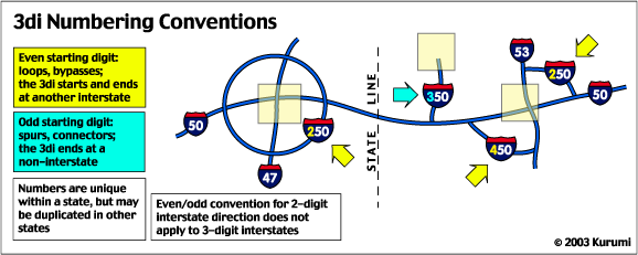
Some places have connectors with three digits. Loops are designated with the number of the main route and an even number prefix. For example, I-405 circles east of Seattle, connecting with I-5 at both points. Radial and spur routes use an odd-numbered prefix. For example, I-105 in Eugene, OR, connects with I-5 at its eastern terminus.
In cases where there are multiple circle/spur routes intersect a major freeway, different prefixes are used. For example, in northern California, you have I-280, I-480 and I-680. However, the system resets across states — San Diego also has an I-405.
Got it? Okay, here are some exceptions.
The interestate system is 46,726 miles and worth of some top fives:
(Source: Federal Highway Administration)
Longest Interstate Routes:
I-90 Seattle, WA to Boston, MA 3,020.54 miles I-80 San Francisco, CA to Teaneck, NJ 2,899.54 miles I-40 Barstow, CA to Wilmington, NC 2,555.40 miles I-10 Los Angeles, CA to Jacksonville, FL 2,460.34 miles I-70 Cove Fort, UT to Baltimore, MD 2,153.13 miles Shortest (2-Digit) Interstate Routes:
I-73 Emery to Greensboro, NC 12.27 miles* I-97 Annapolis to Baltimore, MD 17.62 miles I-99 Bedford to Bald Eagle, PA 53.00 miles* I-19 Nogales to Tucson, AZ 63.35 miles I-66 Strasburg, VA to Washington, DC 74.80 miles (* Additional miles of I-73 in NC and I-99 in PA are expected to be built) East-West Transcontinental Routes:
I-10 Los Angeles, CA to Jacksonville, FL 2,460.34 miles I-80 San Francisco, CA to Teaneck, NJ 2,899.54 miles I-90 Seattle, WA to Boston, MA 3,020.54 miles North-South Transcontinental Routes:
I-5 San Diego, CA to Blaine, WA 1,381.29 miles I-15 San Diego, CA to Sweetgrass, MT 1,433.52 miles I-35 Laredo, TX to Duluth, MN 1,568.38 miles I-55 New Orleans, LA to Chicago, IL 964.25 miles I-65 Mobile, AL to Gary, IN 887.30 miles I-75 Miami, FL to Sault Ste Marie, MI 1,786.47 miles I-95 Miami, FL to Houlton, ME 1,919.74 miles
States with Most Interstate Mileage:
Texas 17 routes 3,233.45 miles California 25 routes 2,455.74 miles Illinois 23 routes 2,169.53 miles Pennsylvania 22 routes 1,759.34 miles Ohio 21 routes 1,572.35 miles
States with Most Interstate Routes:
New York 1,674.73 miles 29 routes California 2,455.74 miles 25 routes Illinois 2,169.53 miles 23 routes Pennsylvania 1,759.34 miles 22 routes Ohio 1,572.35 miles 21 routes
Most Costly Routes (Eligible for Interstate Construction Funds Based on 1991 Cost Estimate):
I-95 Miami, FL to Houlton, ME $8.0 B I-90 Seattle, WA to Boston, MA $7.5 B I-75 Miami, FL to Sault Ste Marie, MI $5.1 B I-10 Los Angeles, CA to Jacksonville, FL $5.0 B
interstate numbering:
The prefixes (eg “4” for 405) are different across states, but generally start with the lowest number. Odd numbers are EW routes, even numbers are NS routes. In other words, 105 isn’t a valid interstate number (please correct me if I’m wrong).
405 belongs to Seattle because 205 is already taken, down in the Portland-Vancouver sprawl.
botts dotts:
They are not simply attached with “adhesive”. Rather, a two-part epoxy is used. This stuff is stronger than the plastic, and ‘dries’ (cures) using a chemical process, rather than evaporation (like your Elmers glue).
paint and striping:
There is a small section of I5 used for striping testing somewhere south of Seattle. IIRC, it’s somewhere near mile marker 100, northbound lanes only. In the past few years, it hasn’t been used much. In the past, I can remember lanes being covered in various stripes. The stripes were perpendicular to the roadway.. I think they are still there, but the vehicle tracks/ruts have worn through a lot of it.
“stripe tape” is more slippery than paint, making lane changes in slick conditions a little more fun, especially in a Miata or on a bike.
regional differences:
On the northwest coast, freeways are generally referred to as “I-5”. In the southwest, “405”, or “The 405”, or “The San Diego Freeway” is the more common term. It’s a little confusing to be in Los Angeles and hear a reference to “The San Diego Freeway”. It’d be like calling 405 in Seattle “The Longview/Kelso Freeway”.
other notes:
Jim may not be 100% human.
> 105 isn’t a valid interstate number
I-105, a spur from I-5 near Eugene, Oregon, was the example I was thinking. I-184 in Richland is another example. Both are east-west.
> regional differences
When I lived in Houston, there was only one loop, I-610, which was referred to things like: “West loop north” — which refers the western segment of loop 610, inside section. Others I-45 north: North freeway, I-45 south: Gulf freeway. I-10 west: Katy freeway. Etc.
> not simply attached with “adhesive”
Yep. I was simplifying the procedure. The snow plowable dots require cutting divets into the road.
> Jim may not be 100% human.
Ssshhhhh! 🙂
oh, and the best freeway exit. It’s on I-15 between LA/SD and Las Vegas.
http://www.schweich.com/imagehtml/1440-11.html
You’re right- there are some weird numbering exceptions. C’est la vie.
I remembered one other significant regional difference: in the west, you don’t slam on the gas as soon as the light turns green. Once your light turns green, you need to wait for the four cars that will be running the light. _Then_ you can go.
In the east, if you haven’t anticipated the light going green, and hit the gas before the light actually turns green, you will hear honking behind you.
And California drivers aren’t the worst. Yes, they are bad, but try driving in Salt Lake City.
Does saying “c’est la vie” make me a terrorist?
> Does saying “c’est la vie” make me a terrorist?
No more than singing “Qu’est Que C’est” makes you a psycho killer.
At least you weren’t hit by one of the mammoth road reflectors:
http://www.nbcsandiego.com/news/2752636/detail.html
What do blue refectors on small streets (i’v only seen them in resedential suberbs) mean? Do they have a reason of is my city trying to control a budget serplus?
Blue reflectors are used to mark the location of fire hydrants. They’re also used (versus red or yellow) when driveways connect to highways because they don’t look like oncoming lights.
I noticed driving home from work the other night that some road reflectors are brighter than others. Like on one road they are there, but have little to no reflection, yet a recently repaved and expanded road, you can see them from like a mile away, do they lose their reflectiveness or something??
I think the light things on the street are a great idea. But there is one problem. I am in Air Force ROTC for my high school. Today was the Christmas parade so of course we had to march in that. Well, half way through marching I fell over one of the light things in front of hundreds of people. Now Im not trying to say they are bad. Maybe they need to be made where they do not stick out of the ground now. Thanks.
-Becky
I had heard (possibly urban legend) that the interstate numbering system is not only consecutive from south to north and west to east but that the actual numbers were chosen as they represent the percentage of land mass they bisect i.e. I-5 is east of 5% of the land in the US. Similarly I-10 is north of 10% of the land. Any idea?
Nice site to find, Jim. I am a roadstriping guy from way-back, now living in NYC metro area. Began working for Chicago area contractor in 1975. Moved to Bay area CA in 1983 and sold interest in pavement marking contracting firm there in 1999 to start consulting business. Moved to NYC in 2001. Always looking for highway related info on net.
Will expect to have my own site up sometime in ’06 with pavement marking related specialty equipment offered. Love your tag line….”Any weekend that starts with a HAZMAT suit has got to get better…” I remember the DOT line here in NY, ” Suit up, guys, we’ve got a tree down…” HAHA!
Best to you.
Question:
I’m building a model train layout set in Texas in the mid 50’s and, in order to build the roads, I need to know what the striping schemes and rules were back then. Do you have any information on this.
Thanks much in advance..
Joe C.
what are the green reflectors on the street for. I know blue to mark fire hydrants; but now I’m seeing some that are kind of blue green turquoise color. There are usuually three of them at a time
When President Eisenhower went to Kansas to announce the interstate highway system, he announced it as “the National Defense Highway System.” In 1956 President Eisenhower signed legislation establishing the National System of Interstate and Defense Highways (about 41,000 miles of roads). Since then, DOD has continued to identify and update defense-important highway routes. The National Defense Highway system was designed to move military equipment and personnel efficiently.
President Eisenhower renamed it the Interstate Highway System.
During World War II, Gen. Eisenhower saw the advantages Germany enjoyed because of the autobahn network. He also noted the enhanced mobility of the Allies when they fought their way into Germany.
These experiences shaped Eisenhower’s views on highways. “The old convoy,” he said, “had started me thinking about good, two-lane highways, but Germany had made me see the wisdom of broader ribbons across the land.”